Services Offered

Boundary Surveys

Boundary Retracement


Boundary retracement is performed to illustrate existing property lines of a current parcel. It’s beneficial to have a retracement survey performed when construction of any improvements on a parcel is going to be done to make sure it is being completed on the owned property and help prevent potential disputes. This requires finding any existing monuments and setting new monuments that are lost. Clients can request lines to be marked with wooden stakes at any noted interval. A survey map will be produced showing any relevant details discovered during the survey. The legal description on older parcels may not meet current county/state requirements, so it is beneficial to get a new one written during a retracement survey.

Consolidation Surveys


Consolidation surveys take existing parcels and combine them into one continuous tract of land. Many homeowners acquire multiple parcels over the course of owning real estate. Combining all the parcels into one can allow the landowner to build improvements over existing parcel lines. Municipalities have different requirements for consolidation surveys and ECH will work with them to get the approvals needed. A legal description and map of consolidation will be provided for filing. Staking out of the property lines can also easily be done at the completion of a consolidation survey.

Plat/Replats


Along with consolidation and subdivision surveys, ECH can provide plat and replatting surveys to reconfigure existing real estate. Plats are used to create multiple lots from an existing parcel. Replats can take existing platted lots and combine them into one lot. In both instances, careful planning with a client’s respective township/county planning commission is required for the approval process.
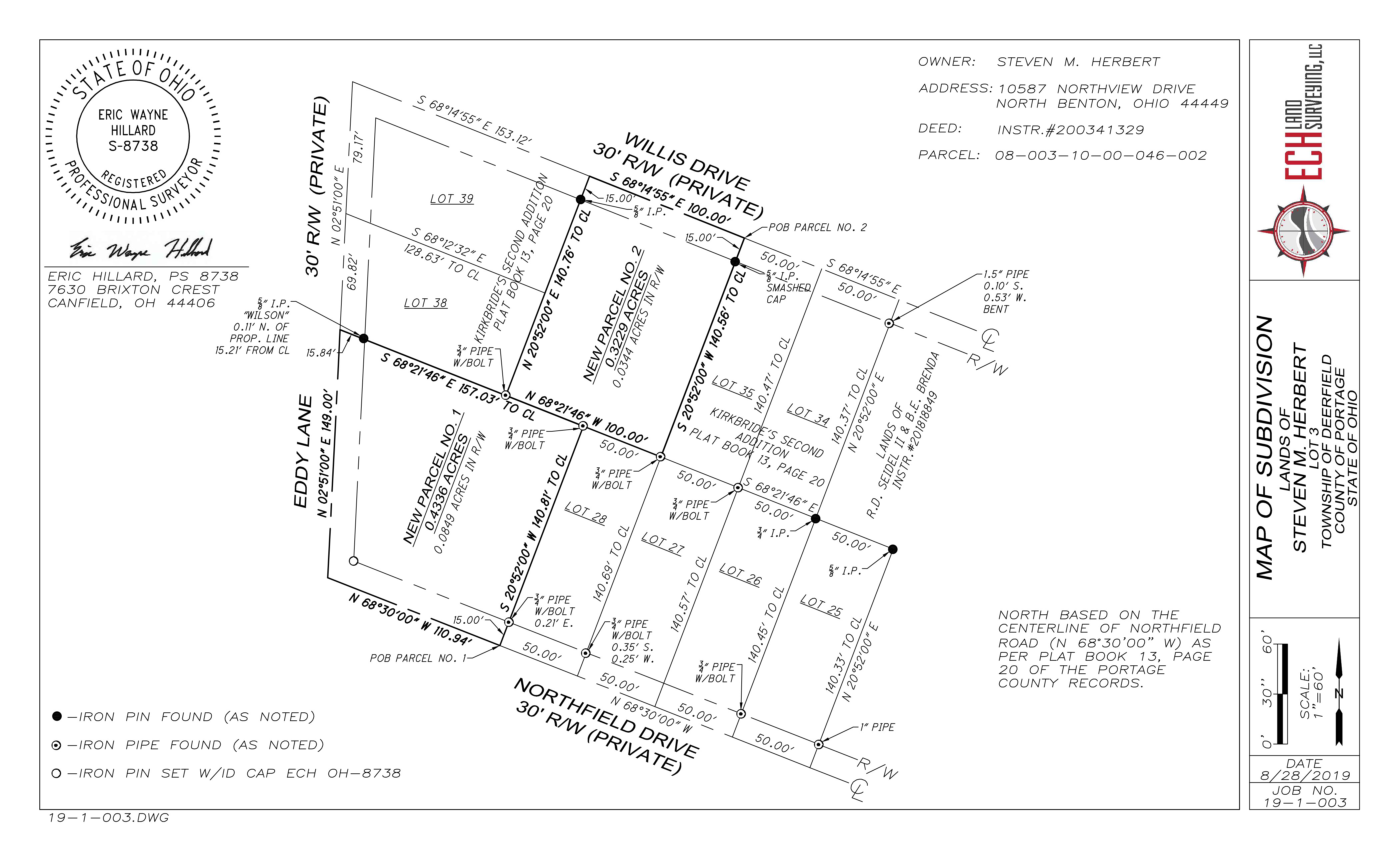
Subdivision Surveys


Subdivision surveys take an existing parcel and create a new tract of land from the existing parcel. If a landowner wants to sell a portion of their parcel, they can request a subdivision survey. There are many requirements for a subdivision to be approved by a municipality and ECH will work to make conforming lots. Legal descriptions and a map of subdivision will be provided for filing. Staking out of the property lines can also easily be done at the completion of a subdivision survey.

Mortgage Location Surveys

Mortgage location surveys (MLS) are requested by mortgage companies in the state of Ohio. This provides proof to mortgage companies that improvements are on the property as described in the mortgage. Mortgage location surveys do not constitute a boundary survey and should not be used for the construction of improvements. ECH provides MLS surveys in a timely manner to help expedite real estate closings.

ALTA/NSPS Land Title Survey

ALTA/NSPS Land Title surveys are used when commercial property is being refinanced, sold, or developed. Banks financing these large transactions want to be sure the property is free of encumbrances. These complex surveys show all improvements, easements, boundary line locations and encroachments onto the subject property. Extensive review of title documents will occur and be included in the final preparation of the survey documents. ECH can provide ALTA surveys and work with title companies and lenders to provide timely service with completing commercial real estate transactions and developments.

ALTA/NSPS Standards

Topographic Surveying

ECH Land Surveying, LLC provides topographic surveying to residential, commercial, industrial, and government entities for development of land and improvements to land. Topographic surveys provide the location of natural and artificial features of a given area. ECH works with a civil engineer or architect to provide deliverables curtailed to the specifications needed for a given project. Using AutoCAD, Civil3D base maps are drafted to specified standards. Using a combination of optical and GPS/GNSS measurements, base maps are produced to the given accuracy required for the project. Boundary surveys can be performed in conjunction with the topographic survey to efficiently complete site improvements.

Construction Stakeout

ECH can provide construction staking services to general contractors. We will work with the owner/foreman to provide understandable survey layout to help expedite construction work for homebuilders to large commercial construction companies.

FEMA Flood Surveys

FEMA flood certificates are utilized to determine cost associated with a flood insurance policy. When buying a new house or refinancing a mortgage loan, lenders will require a FEMA flood survey if the property is in a possible flood plain. ECH will collect the necessary data to complete a flood certificate survey.

FEMA